Utah’s window for lift-served powder days runs from late Sunday night through Tuesday afternoon (April 12-14, 2026), and the upper Cottonwoods are the clear winners.
Snow starts relatively warm and wind-affected, then improves as colder air settles in, with Alta favored for 5-9 inches, Snowbird 5-8 inches, Brighton 5-7 inches, and Solitude 4-7 inches by Tuesday afternoon.
Monday should ski softer than it looks on paper, but it is still the windier and denser part of the cycle. Tuesday is the cleaner day, with lighter snow, lower snow levels near 6,000 feet, and better preservation in sheltered terrain. Confidence is highest from late Sunday night through Tuesday afternoon. Confidence drops after Tuesday, although another colder wave from Thursday into Friday remains on the table.
Powderchasers/WeatherBell
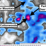
Utah Ski Resort Snowfall Totals (April 13-14, 2026)
These totals err on the conservative side. Reported totals will likely end up on the higher side of or exceed these ranges.
- Beaver Mountain: 2 inches (closed)
- Powder Mountain: 2-3 inches (closed)
- Deer Valley: 2-4 inches (closed)
- Park City: 3-5 inches (closed)
- Solitude: 4-7 inches
- Brighton: 5-7 inches
- Eagle Point: 5-8 inches (closed)
- Snowbird: 5-8 inches
- Alta: 5-9 inches
Storm Timing and Discussion
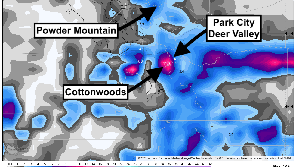
The early-week storm has the tightest agreement. Snow breaks out late Sunday night, fills in through Monday, and tapers Tuesday afternoon. Guidance is fairly well converged on the main timing, on snow levels falling from roughly 7,500-8,000 feet at the start to around 6,000 feet by Tuesday morning, and on a windy start that eases as the storm matures. That keeps the upper Cottonwoods in the sweet spot, where Alta can reach 5-9 inches by Tuesday afternoon, Snowbird 5-8 inches, Brighton 5-7 inches, and Solitude 4-7 inches.
The intensity spread is wider once you move away from the Cottonwoods. Some solutions still paint useful snow into Eagle Point and the northern fringe, while others keep those areas modest, and the Park City side remains more marginal with warmer air early in the event. Much of that non-Cottonwood terrain in this data set is already closed, so from a practical skiing standpoint, the focus stays on Alta, Snowbird, Brighton, and Solitude.
A second wave is still favored from Thursday into Friday, but the guidance is more scattered on both placement and totals. Most solutions bring a sharper shot of cold air, snow levels falling from around 7,500 feet to below 4,000 feet, and improving snow quality as winds back off behind the front. The realistic outcome right now looks like a modest refresh rather than a major cycle, with roughly 4-8 inches possible in the upper Cottonwoods and lower totals on the Park City side if the storm holds together.
Daily Chase Recommendations
Each day’s snowfall range combines the previous night (4 p.m.-8 a.m.) and that day (8 a.m.-4 p.m.).
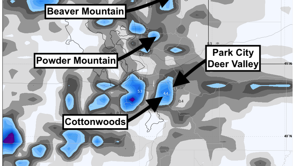
Monday, April 13, 2026
Powderchasers/WeatherBell
Alta and Snowbird are the Monday call with 3-4 inches of moderate-to-heavy snow and the best chance to stack fresh turns, but strong ridge wind will keep the softest skiing in sheltered terrain.
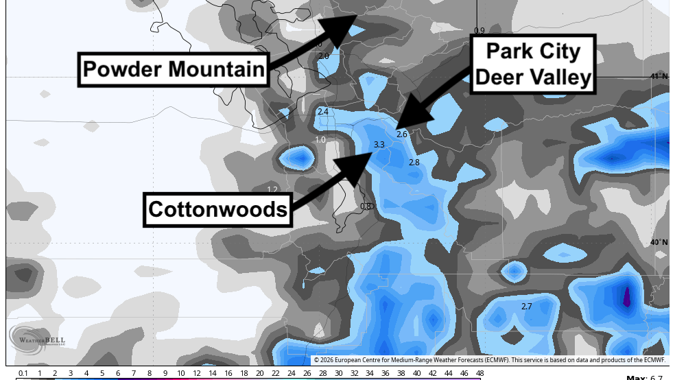
Tuesday, April 14, 2026
Powderchasers/WeatherBell
Alta and Brighton should offer the best turns on Tuesday with 3-5 inches of lighter snow and much calmer wind on top of Monday’s refresh.
Extended Outlook
After Friday, the broader pattern keeps Utah near seasonable temperatures with periodic mountain snow chances rather than a locked-in dry stretch. The next week still leans somewhat active across the Great Basin, but the longer-range signal over Utah trends closer to near normal, so expect intermittent minor refresh opportunities instead of a sustained multi-storm cycle; there is another late-period signal in some guidance, but it is too inconsistent to sharpen beyond that.
Related: Snow Expected In Colorado This Weekend, but Most Resorts Are Closed