The Sierra finally flips back into storm mode, but the meaningful snow arrives on Tuesday, and then builds through Thursday (March 31-April 2, 2026).
Storm totals have dropped since our 10-day forecast of the storm, however.
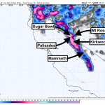
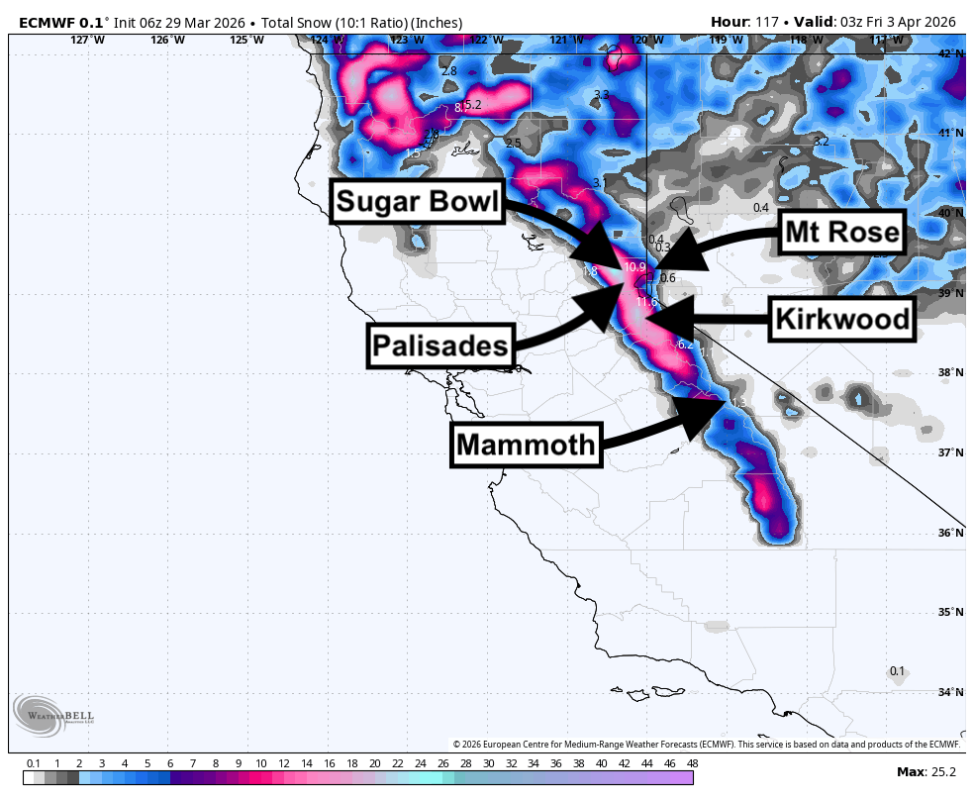
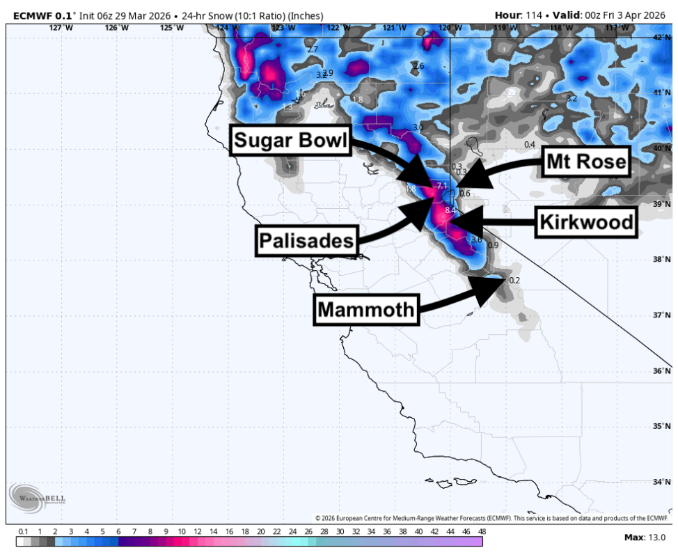
Kirkwood is the clear standout, with Sugar Bowl and Palisades Tahoe next in line once colder air pushes deeper into Tahoe. Mammoth does well early, but the longer and colder part of the cycle favors the Tahoe crest.
Snow quality starts dense to heavy, then improves a bit as snow levels fall from roughly 7000-8500 feet on Tuesday to around 4500-6500 feet by Thursday.
Ridge gusts push into the 50-70 mph range and run higher on exposed east-side peaks, so wind will matter throughout this cycle. Confidence is highest from Tuesday morning, March 31, through Thursday evening, April 2, when the storm structure and falling snow levels are most consistent.
Ski Resort Snowfall Totals (Mar 31-Apr 2, 2026)
- Mammoth: 5-7 inches
- Palisades Tahoe: 6-10 inches
- Sugar Bowl: 7-12 inches
- Kirkwood: 10-18 inches

WeatherBell/Powderchasers
Storm Timing and Discussion
The first push arrives Tuesday. Guidance is fairly well aligned on timing and on a ramp-up in ridge wind, with snow breaking out first over the highest terrain before spreading across more of Tahoe later in the day. Guidance is less aligned on intensity, but it converges on a warm start, with snow levels mostly around 7000-8500 feet and the best early turns limited to higher elevations. That keeps Tuesday’s snow dense to heavy, with Mammoth and Kirkwood favored first while lower Tahoe bases stay marginal.
The bulk of the cycle runs from Tuesday night through Thursday evening. Guidance converges on colder air, broader coverage, and a clear drop in snow levels toward 4500-6500 feet by Thursday. Guidance still diverges on exact totals, especially at Kirkwood and along the Tahoe crest, but it agrees on strong wind impacts, with ridge gusts around 50-70 mph and locally over 80 mph near the east side.
Kirkwood should finish around 10-18 inches by Thursday evening, with Sugar Bowl in the 7-12 inch range, Palisades Tahoe in the 6-10 inch range, and Mammoth in the 5-7 inch range. Mt. Rose and Heavenly stay much lighter and take more of a wind hit, so the best skiing should center on the western and southern Sierra resorts.
Daily Chase Recommendations
Each day’s snowfall range combines the previous night (4 p.m.-8 a.m.) and that day (8 a.m.-4 p.m.).
Wednesday, April 1, 2026
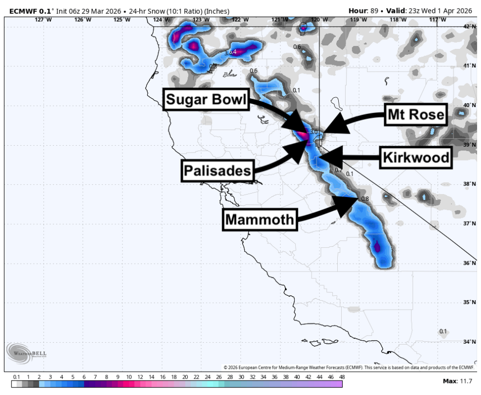
WeatherBell/Powderchasers
Kirkwood is the top call for Wednesday with 4-9 inches of heavy snow, the best overall stack, and less wind trouble than the more exposed east-side hills.
Mammoth is a solid secondary play for Wednesday with 3-4 inches of heavy snow, colder temperatures, and lighter wind than Tahoe.
Thursday, April 2, 2026
WeatherBell/Powderchasers
Kirkwood stays in front Thursday with 5-8 inches of heavy snow, but strong ridge gusts will keep the upper mountain rough.
Sugar Bowl is the backup Thursday with 5-8 inches of heavy snow and a better shot at softer trees than the windier east-side terrain.
Extended Outlook
Snow shuts down quickly after Thursday night, and Friday through the weekend trends warmer, drier, and quieter with lighter winds after an early ridge-top breeze. Early next week still leans mostly dry, with only a weak and low-confidence signal for light snow around Tuesday. The bigger pattern beyond that favors above-normal warmth and below-normal precipitation across California, so this midweek cycle looks like the best powder window for a while.
Related: We’re Heading To Grand Targhee This Week To Test 44 of Next Year’s Skis