You’ve probably seen the news by now. Some monstrous thing called a “Super El Niño” is coming, and it’s going to wash every ski resort on the continent into the sea.
I’m only joking. Still, researchers of all kinds are watching the ocean closely. Based on the current data, this isn’t looking like an El Niño that neglected to hit the gym and bulk up.
Instead, in the fall and early winter, there’s about a two-in-three chance it qualifies as “strong” or “very strong,” according to the latest update from the Climate Prediction Center. It may even be an El Niño of historic magnitude.
Around the world, that could set the stage for droughts, wildfires, flooding, and record-hot global temperatures—all serious events that go far beyond the importance of floofy powder turns.
And yet, amid the prospective bedlam, I found myself asking experts about what this El Niño might mean for the upcoming ski season here in the U.S.
Sometimes, being a ski writer means sticking your head in the snow. Having conversations, though, can also serve up reminders that, no matter how heavenly it is, skiing will always be connected to all kinds of turmoil here on Earth. Thanks for that, El Niño.
Anthro/Getty Images
Pack Your Powder Skis, or Don’t
First, what is El Niño?
The climate phenomenon is a phase in the El Niño-Southern Oscillation, or ENSO. The cycle, which flip-flops on an irregular, multi-year scale, revolves around a patch of ocean in the equatorial Pacific.
The surface temperature of those waters sometimes rises or falls above or below average. When they’re warm for a long enough stretch—and the right atmospheric signals are in place—scientists announce that El Niño has come to town. The opposite is true of El Niño’s sibling, La Niña. Both have documented impacts on U.S. winter weather patterns through a phenomenon called “teleconnections.”
It’s like “if you throw a rock into a lake, you would see ripples coming out from where the rock landed,” Aaron Levine, a research scientist at the University of Washington who studies ENSO, told me.
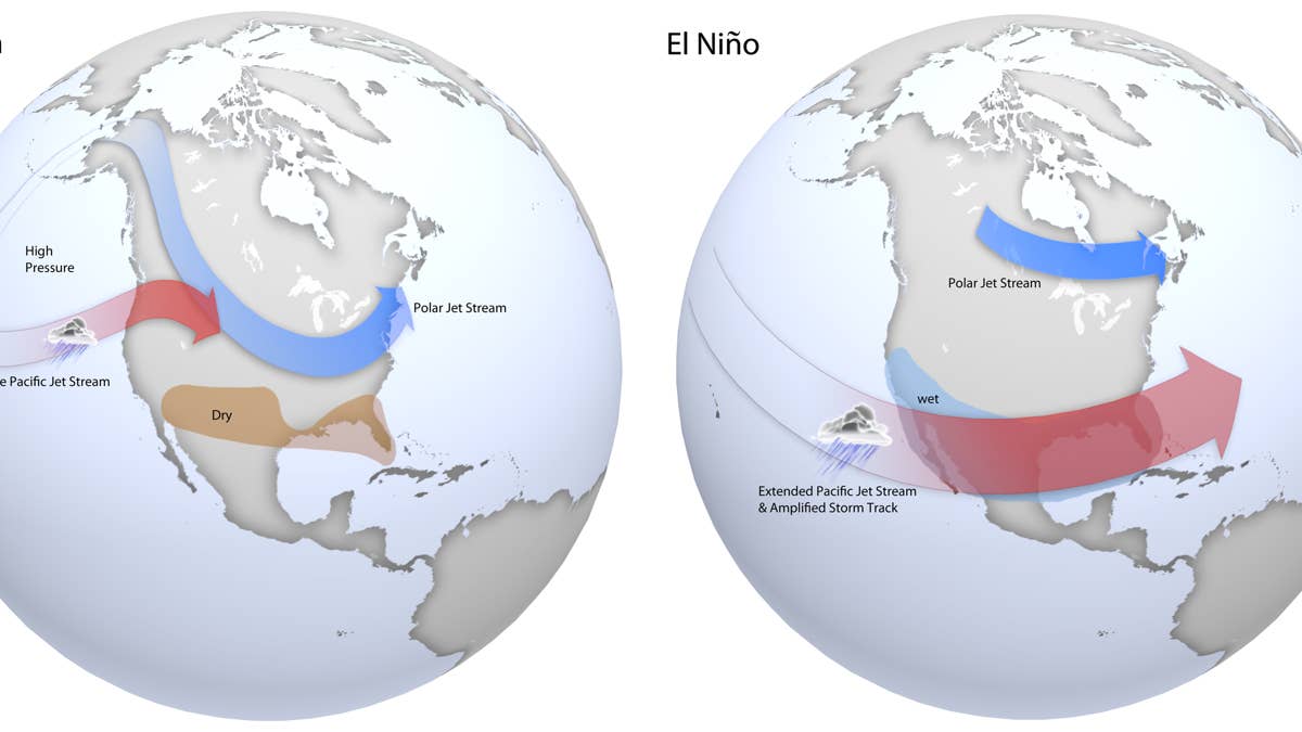
Specifically, El Niño has a habit of boosting one of North America’s primary jet streams, the subtropical jet. This fast-moving river of air hovers miles above the ground and acts like a storm highway, steering weather systems across the southern half of the U.S.
NWS
Because of that influence, parts of the U.S. tend to have a wetter (read: hopefully snowier) winter during El Niño, especially in Southern California, the Southwest, and the Southeast U.S., explained Alan Smith, a meteorologist and the operations manager at OpenSnow, offering a broad overview.
“On the other hand,” he continued, “you often get more high-pressure dominant patterns over the northern U.S. and Canada, so that can lead to winters that are favored to be warmer than average across the northern tier, and oftentimes drier than average, too.”
Meteorologists consider El Niño and La Niña valuable tools in the challenging game of longer-term thinking. They aren’t a wild shot in the dark, and they provide some clues as to how winter may pan out months in advance—without resorting to a Magic 8 Ball, that is. Chris Tomer, a meteorologist and name you might recognize because of his popular snow forecasts on YouTube, said ENSO is one of the first things he looks at when preparing a season outlook.
Forecasters don’t take these patterns as gospel, though, and you shouldn’t, either. Neither ENSO phase deals in certainties. Instead, it’s helpful to think of El Niño as a stacked deck put together by someone who hasn’t quite mastered stacking decks.
“Everything’s a probability game in the world of meteorology and climate, and this is certainly one of those,” said Tomer.
Roberto Machado Noa/Getty Images
Supercharged El Niño?
Not every El Niño is created equally.
The Climate Prediction Center puts each in one of four buckets: “weak,” “moderate,” “strong,” and “very strong.” The last category means about the same thing as “Super El Niño”—it’s a big one, basically. However, official groups like NOAA and the World Meteorological Organization don’t use “super” to describe El Niño, as it’s unscientific.
“We’re just hearing the term ‘Super El Niño’ because that garners more interest,” noted Smith.
Each bucket on the Climate Prediction Center scale corresponds with sea surface temperatures. The warmer those temperatures get, the stronger a given El Niño is. To cross the “very strong” threshold, temperatures have to equal or exceed two degrees above average.
Per the Climate Prediction Center, either a “strong” or “very strong” El Niño is the likeliest outcome this fall and winter, as of now. Some forecasts call for an unprecedented ocean temperature increase of three degrees. That’s important because, generally, powerful El Niños hit the atmosphere harder, reinforcing the expected patterns.
In terms of the 2026-27 ski season, this could translate “to a greater chance that the storm track will shift to this more southern location for a greater percentage of the time in winter,” Levine said. “But,” he added, that doesn’t necessarily mean “you’re going to see a historic precipitation anomaly.”
Anomalous or not, precipitation can be fun for skiers. Without cold temperatures, though, storms are only an opportunity to test how waterproof your Gore-Tex is.
Tomer thinks there may be a problem with that next winter. With the current setup, he said, the lower 48 could be looking at a blanket of warmth. While Tomer seems bullish on above-normal precipitation in places like California’s Sierra Nevada mountain range, he wondered about freezing levels, even as he acknowledged that temperature questions are difficult to answer at this point.
“When you really juice up the southern branch of the jet stream … you’re just bringing in a ton of warm air into the country,” he said.
The strength of this El Niño also isn’t a sure bet. While El Niño seems all but guaranteed, Levine carefully pumped the brakes on the supercharged buzz. He explained that in the spring, El Niño forecasts are at their least certain. In recent weeks, the Climate Prediction Center offered a similar sentiment, noting that “there is still substantial uncertainty in the peak strength of El Niño.”
Levine did concede that given the current conditions, there’s a reason for hype. But he said he would “tone back” on that hype a little bit. The question, then, doesn’t seem to be whether an El Niño of any strength shows up—the Climate Prediction Center has pegged those odds above 90%—it’s how intense that El Niño becomes.
Any discussions of ENSO will, as you can hopefully tell, be steeped in chaos, caveats, and qualifiers. Everyone I spoke with made that clear. And, of course, you have to take the time of year into account. Tomer doesn’t plan to publish an outlook for next winter until July at the earliest. Smith and OpenSnow are looking at August. We still have a long way to go before ski resorts announce their opening dates, let alone blow snow.
Still, I hoped, naively, to come away with something concrete. So, I put the question to Smith: Is there anything he could guarantee right now? He had an encouraging take. Perhaps unsurprisingly, though, it wasn’t related to El Niño.
“Statistically speaking, it’s very likely that this winter is going to be better than last winter, because last winter, at least from a West-wide perspective, was about as bad as it gets,” Smith said, laughing. “Having two winters in a row like that is extremely unlikely. So, I feel confident that this is going to be better than last season.”
Related: I Moved Away From the Mountains, But My Ski Dreams Won’t Let Me Go