Updated August 3, 2026 04:48PM
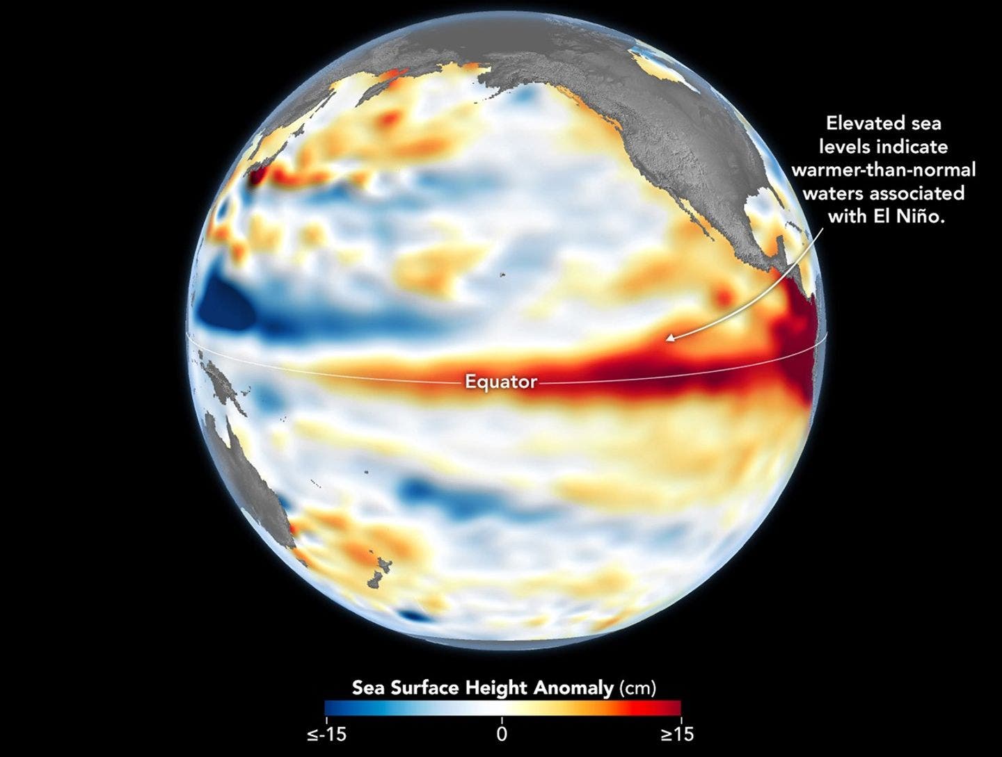
Back in the spring, forecasters began warning that this winter could feature one of the strongest El Niño events in history. Since then, skiers have been trying to answer one question: Where can I go for the best chance of cashing in?
While we offer our best educated guesses here, the reality is it’s still too early to tell you with extreme confidence to book your flights and hotels to any particular location.
While NOAA is increasingly confident that an exceptionally strong El Niño will indeed dominate the entire 2026-’27 ski season—from early fall through early spring—it turns out that the strength of the event tells us surprisingly little about where the most snow will actually fall.
Here’s What We Do Know
Forecasters are more confident than ever about a very big El Niño.
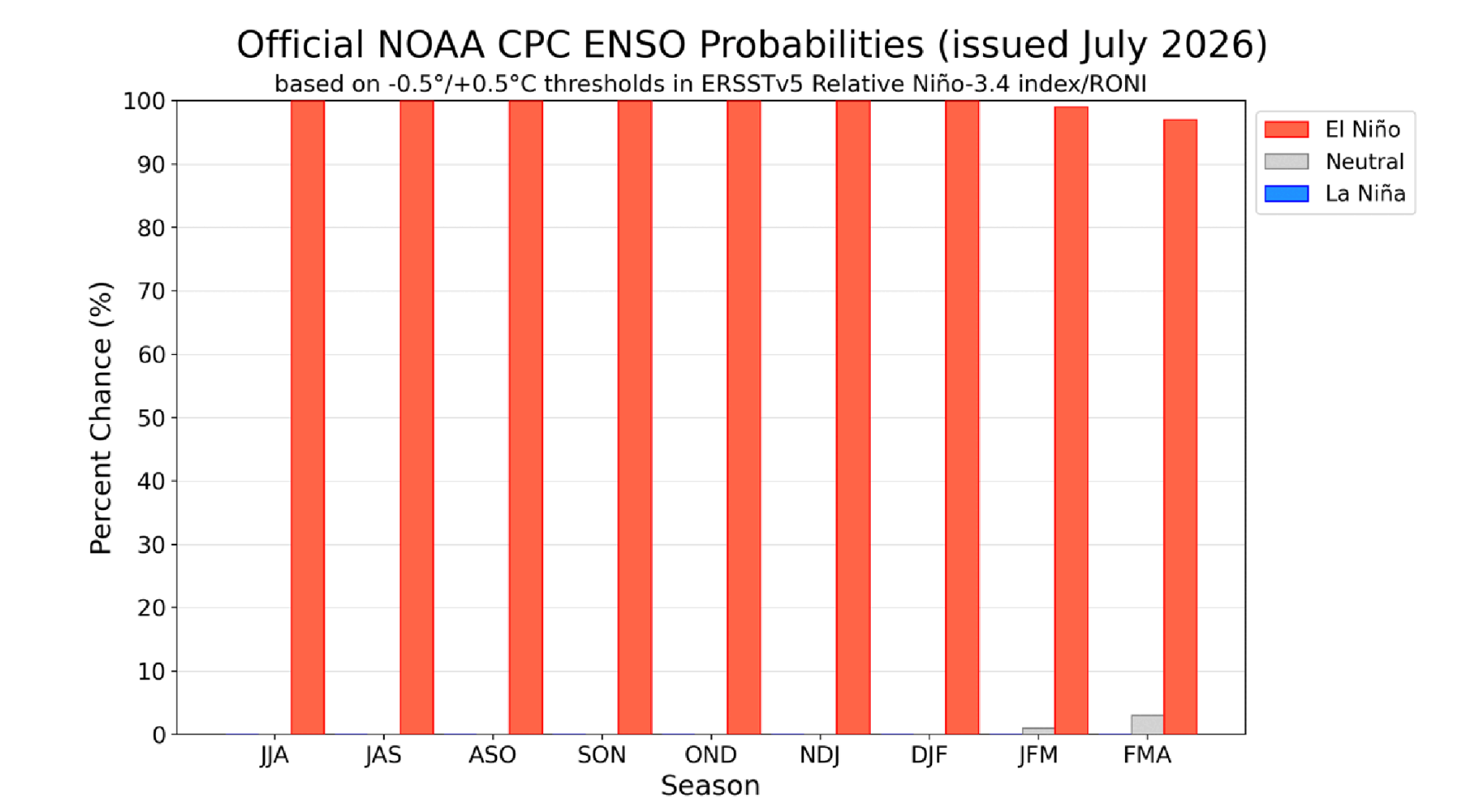
According to NOAA, there’s a 97 percent chance the climate pattern persists through early spring 2027, meaning it should leave its mark on the entire ski season.
NOAA also puts the odds of the event reaching “very strong” status at 81 percent during the fall, with the climate signal expected to peak between October and December before gradually weakening throughout the winter. That timing is notable because its strongest influence is expected to hit around the start of ski season—late October and November—not during peak ski months.
In other words, confidence in the El Niño itself is growing. What remains far less certain is what that will mean once winter storms begin taking shape over North America.
A Bigger El Niño Doesn’t Mean a More Accurate Snow Forecast
While it seems logical that a stronger El Niño would make this winter’s snowfall easier to predict, in reality, the opposite is true.
“The strength of an El Niño tells you how loaded the dice are,” says Nick Russill, meteorologist at Snow-Forecast.com. “It doesn’t tell you which way they’ll land.”
El Niño can tilt the odds toward wetter or drier conditions, but it doesn’t determine where storms actually track, explains Russill. That’s still up to the atmosphere—specifically the jet stream and other weather patterns that remain impossible to forecast this far in advance.
That’s why NOAA’s outlook shows no clear precipitation signal for popular ski destinations like Colorado, Utah, and Tahoe. “Equal chances” doesn’t mean an average winter; it means the models don’t have a strong lean either way. One persistent storm track can quickly turn an uncertain forecast into a banner season—or a disappointing one.
In other words, this winter’s exceptionally strong El Niño is an important clue, but not a guarantee. It may load the dice, but Mother Nature will have the final roll.
History Says Don’t Bet the House
If you’re tempted to start planning a powder trip based solely on this year’s El Niño forecast, recent history offers a reminder not to jump the gun.
Ahead of the blockbuster 2015-’16 El Niño, forecasters widely expected a classic pattern: a dry Pacific Northwest and a stormy California. Instead, the opposite occurred. The Northwest finished wetter than expected, while Southern California failed to deliver the drought-busting winter many had predicted.
So what happened?
According to a NOAA-supported study published after the season, the issue wasn’t the strength of the El Niño; it was the atmosphere. Researchers found that unpredictable shifts in circulation over the northeastern Pacific largely determined where the storms tracked, overwhelming the broader climate signal that El Niño provided.
The takeaway for skiers is simple: El Niño can stack the odds, but it doesn’t call the shots. In fact, the study found that even in Southern California, where El Niño has its strongest influence, the trend explains only a fraction of a winter’s precipitation. Farther north, in places like Tahoe, that relationship becomes even weaker. That’s why this winter’s forecast still comes with plenty of uncertainty, no matter how impressive the headlines may be.
So Where Is It Most Likely to Snow?
While the overall winter forecast remains uncertain, NOAA’s latest outlook does show some regional differences. Right now, the strongest signal favors the Southwest, while the northern mountains face the biggest challenges.
The early favorites: Arizona, New Mexico, and southern Utah
The Southwest is the region with the most encouraging setup right now. NOAA is calling for above-normal precipitation across Arizona and New Mexico, with temperatures trending closer to normal by midwinter. That puts places like Taos, Ski Santa Fe, and Arizona Snowbowl in a good position heading into the season.
The question marks: Colorado, northern Utah, and Tahoe
For some of the West’s most popular ski destinations, the forecast is less clear. NOAA currently sees “equal chances” of above-, below-, or near-normal precipitation across Colorado, Utah, and the Tahoe region.
That doesn’t mean an average winter is expected; it means the models don’t have a strong enough signal to favor one outcome over another. A well-timed storm track could still produce an exceptional season—or leave resorts wanting for more.
The most risky: Washington, Oregon, Idaho, and Montana
The Pacific Northwest and northern Rockies carry the clearest warm signal in NOAA’s outlook, with above-normal temperatures and below-normal precipitation favored through the winter. The challenge for these resorts may not be a lack of snow entirely, but warmer conditions that could mean wetter storms and more challenging conditions on lower-elevation terrain.
For skiers, the message is clear: elevation matters, and this year more than ever, where you ski may matter as much as when you ski.
Why Colorado Is Basically a Coin Flip
As much as we’d like to say that we’re expecting Colorado’s resorts to make out well, it’s pretty 50/50 at the moment according to Russill. With no significant precipitation signal and warmer temperatures expected, elevation and other factors become more significant, and one storm cycle can change everything.
Following the guidance available so far, stay south for your best bets (Telluride, Wolf Creek, Purgatory) and hold off on booking Front Range and northern destinations until more information becomes available.
What About the East Coast and the Midwest?
The El Niño forecast doesn’t point to a major boost or a major bust for most Eastern ski areas. Unlike the West, where the signal is stronger, the outlook for New England is fairly neutral: There’s no clear indication of a wetter-than-normal storm track, but also nothing pointing toward a dry winter.
The bigger concern is warmth. Mild temps could make it harder for resorts to maintain consistent conditions, especially during marginal early- and late-season periods.
The Great Lakes region faces a slightly tougher scenario. Lake-effect snow depends on cold air sweeping across relatively warm lakes, and an El Niño pattern that favors milder temperatures can reduce that setup. For resorts that rely heavily on lake-effect storms, that could be a limiting factor this winter.
Travel Planning Tips for Winter 2026-’27
To sum things up, here are some actionable takeaways from our friends at Snow-Forecast.com as you sit down to plan your ski trips. The next NOAA outlook will be available on Aug. 13, and we will share additional insights then.
- Opt for resorts in higher elevations
- Favor north-facing terrain
- Keep travel dates flexible
- Treat New Mexico as promising—not guaranteed
- Don’t write off the Pacific Northwest quite yet
- Wait until late October to book, if possible